Sunday, October 28, 2012

New landscaping at Asylum Lake

Western Michigan University's Asylum Lake Preserve had some major trail work done this summer along the east end of Asylum Lake.  Invasive shrubs and trees, like buckthorn, honeysuckle, and Norway maple, were removed to make room for native species.  The trails were re-graded to make them wheelchair accessible, part of a long run plan to make the preserve ADA compliant.  Stone retaining walls will prevent erosion and runoff.

It's nice to see WMU investing in the preserve and the improvements are attractive.  The heavy equipment did tear up the trail along the south side of Asylum Lake, leaving deep muddy ruts and pools of water.  A passerby told me they plan to repair that damage, but he speculated it might have to wait until Spring.


Asylum Lake access & parking: Drake Road, Parkview Avenue, or Winchell Avenue.

Asylum Lake Trail Map 

Thursday, October 25, 2012

Middleville Spring Park

Middleville Spring Park doesn't look like anything special.  Tucked behind a Speedway gas station on M-37 on the southern edge of Middleville, it appears to be a typical small town park with a baseball diamond, some swings and a jungle gym, a picnic shelter, and a few disc golf baskets.  Yet, if you follow an inconspicuous trail, marked only by a small brown notice "MDEQ Wetland Conservation Easement", north from the ball field, you will find a hidden natural gem-- small, valuable, and (in-season) colorful.

Beyond the park is a fen: a rare habitat for some special wildflowers.  Some people call it the Barry County fen and others refer to the Middleton fen.  I don't know if it has an official name and I'm not sure it's officially part of Spring Park but it is open to the public with a few benches, bridges, and a short boardwalk.  Fens are wetlands somewhat like bogs but while bogs are acidic, fens have a neutral or alkaline pH and a high mineral content.

The fen doesn't offer dramatic scenery.  Instead, its beauty is small-scale and requires the viewer to stop and look.  When I visited in September, Fringed Gentians were in bloom all along the creek; orchids and other wildflowers bloom there in other seasons.

Sunday, October 21, 2012

Maas Family Nature Preserve

The Maas Family Nature Preserve north of Rockford made a nice stop on the White Pine Trail.  I didn't know anything about it, but when I saw the sign and a bike rack, I decided to take a break from cycling.  The preserve was small (about 17 acres) and had one footpath crossing the entire preserve.

I noticed native prairie grasses growing amongst the oak trees and realized this was a special environment.  Oak Savannas or Oak Pine Barrens were once common in southwest Michigan.  Development and fire suppression has made these habitats increasingly rare.

Wild Lupine is one of the characteristic wildflowers of this area and it's the critical food for the endangered Karner Blue butterfly.  By protecting this preserve, the Land Conservancy of West Michigan provides habitat for this endangered species.
I'd like to return in May when the lupines are in bloom.

Information on the Maas Family Nature Preserve [pdf]

Thursday, October 18, 2012

Rogue River Nature Trail

The Rogue River Nature Trail isn't a serious hiking trail, but it is a very pretty path along the Rogue River in Rockford, Michigan.  The trail is made of distinct segments, developed over the last few years.  The newest segment is boardwalk on the west bank of the river that was completed in 2012.  Other sections, on the east side of the river, connect downtown shops to nearby playgrounds and parks including Rockford's new dog park.    That trail segment offers several benches and picnic tables near the river.
The combined length of the segments is only about a mile.  For those looking for a longer excursion, the White Pine Trail intersects the Rogue River Nature Trail and runs over ninety miles.

A walkway on dam over the Rogue River connects the different trail sections.
The boardwalk is off-limits to bikes.  For me, that made it an ideal place to stretch my legs after a long ride on the White Pine Trail.  The nature trail was very popular with families and tourists on a recent sunny afternoon.
Rockford is about an hour north of Kalamazoo on US 131.  Follow 10 Mile Road (exit 97) east to Rockford's downtown.

Sunday, October 14, 2012

White Pine Trail

A couple of days ago, I rode from Belmont to Sand Lake on the White Pine Trail.  The  entire trail runs 92 miles from Grand Rapids to Cadillac; the ride I took was about 17 miles (each way), passing through the towns of Rockford,  Cedar Springs, and Sand Lake.  This segment was paved, with a smooth asphalt surface.  Like other rail-trails, the White Pine Trail is fairly straight and level. 

North of Belmont, the trail passed through woods high above the Rogue River, which could be occasionally seen through the trees.  Approaching Rockford (about 4 miles), houses were visible, and then the trail crossed the river on an old iron bridge.

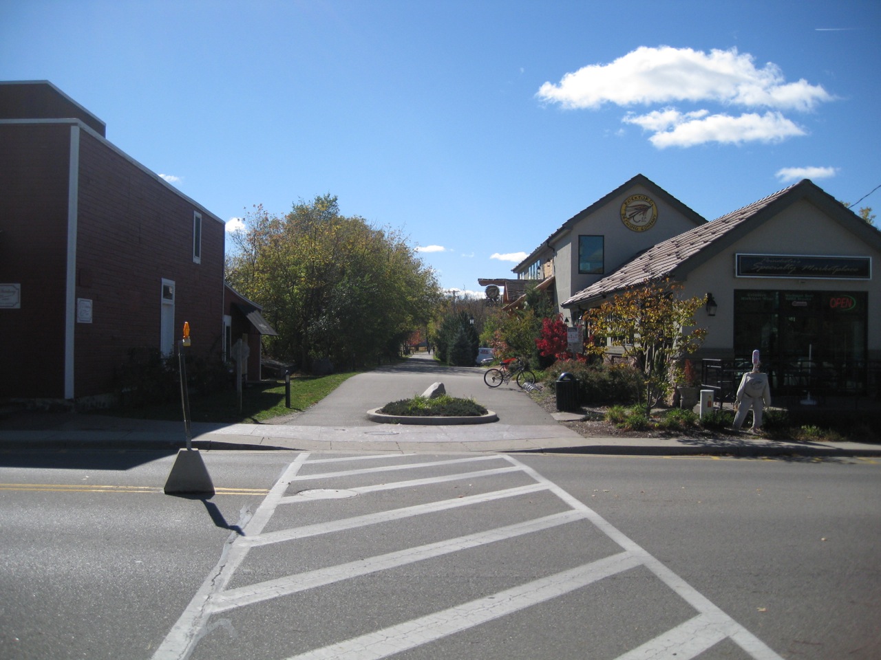
Rockford surprised me.  It felt like one of the tourist towns along the lakeshore, transplanted to the Rogue River.  The industrial buildings once served by the railroad had been repurposed as delis, restaurants, and wine bars.  A microbrewery was under construction right next to the trail and the smell of hops and roasted malt showed they had already begun brewing.  The river runs right through  town and many people were enjoying the nicely landscaped park where a dam creates an artificial waterfall and others strolled scenic paths along the riverbanks. 
North of Rockford, the trail ran alongside the river and then through farmland and forest.  From Cedar Springs,  the trail paralleled Northland Drive all the way to Sand Lake.  Cedar Springs (about 7 miles from Rockford), and Sand Lake (about 5 miles further) seemed like typical rural Michigan towns, with local family restaurants and some small stores.  After Sand Lake, the trail's pavement ended but the trail continued with a gravel surface.  A sign indicated it was 30 miles to Big Rapids.  The gravel/ cinder surface was rideable, but less fun, and I was getting tired at that point, so I only rode a half mile before turning back to Sand Lake.
Overall, this segment made a great ride.  Numerous trailheads provide access to the trail, so either shorter or longer trips could be put together.  Riding south from Belmont, the trail connects to Grand Rapids.

Officially, the trail is the Fred Meijer White Pine Trail State Park.
The Friends of the White Pine Trail provide trail information and promote various events on the trail.
The Rails to Trails Conservancy also has information in the trail, including user reviews and photos.


Belmont Trailhead
Rogue River Park
6300 Belshire Avenue
Belmont, MI 49306


Rockford offers several access points.  [pdf map]

Thursday, October 11, 2012

Oil spill clean-up continues

More than two years after the oil spill, containment booms are still in place on the Kalamazoo River.  Most of the river is open for recreation but workboats and the yellow booms are still very visible from River Oaks County Park.  There are signs saying the river is open, so it is probably possible to navigate through the booms.

The Environmental Protection Agency recently ordered the oil company to continue cleaning its spill.
Apparently the firm plans to build a new pipeline to replace its aging pipeline.

Sunday, October 7, 2012

Sandhill Crane Fall Migration

Sandhill Cranes (Grus canadensis) have already started their migration south.  As these large birds leave their breeding grounds in Michigan and other northern states and provinces to spend the winter in Texas and northern Mexico, or Florida, they gather by the thousands in wetlands along the flyway to feed and rest.  This creates great opportunities to see impressive numbers of cranes in the next few weeks.

Several of these areas are near Kalamazoo.

The closest is the Baker Sanctuary northeast of Battle Creek.  Each year they host Cranefest, which will be October 12-13 this year.  Access is via the adjacent Kiwanis Youth Conservation Area, with the best viewing in the late afternoon to just before dusk as the cranes fly overhead. 
Kiwanis Youth Conservation Area/Baker Sanctuary
22300 15 Mile Rd
Bellevue, Michigan 49021
The Haehnle Sanctuary near Jackson also features thousands of cranes each Fall.  They plan a festival on October 20, as well as tours and events throughout October.
Phyllis Haehnle Memorial Sanctuary
8746 Seymour Rd
Grass Lake, MI 49259
[address is approximate.]

Jasper Pulaski in Indiana is the best-known spot for Sandhill Cranes in the region.  It's about a 2.5 hour drive southwest from Kalamazoo.  Since it is farther south, the peak migration is later, typically in mid-November.
Jasper Pulaski Fish and Wildlife Area
west of US Route 421 
Medaryville  IN  47959 

Thursday, October 4, 2012

Spicebush berries

Fall is the season of many nuts and berries including the eye-catching fruits of the Spicebush (Lindera benzoin)  This shrub grows in partly-shady areas with moist soils.  It's widely distributed in the eastern United States and found throughout southern Michigan.

It blooms in early Spring (mid-March, this year) before the forest leaves have opened.  The flowers, while tiny, are bright enough to make an eye-catching display of yellow among the bare branches.  Later in the year, it's a host plant for the Spicebush Swallowtail butterfly.

The colorful berries (or drupes) are eaten by many different animals and a mixed flock of birds were feeding on them when I saw these.  Apparently people also consume these fruits, using them as a replacement for allspice.  People also make tea from the twigs.  In 2011, the Herb Society named Spicebush the Native Herb of the Year.