Thursday, April 22, 2010

Spring snakes


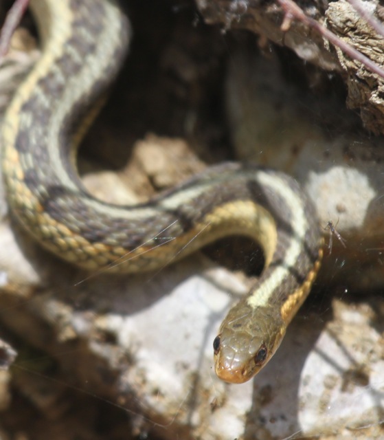
Chipmunks and woodchucks aren't the only animals to emerge in Spring. Garter snakes also spend Kalamazoo's winter in hibernation. I think this one is an Eastern Garter Snake (Thamnophis sirtalis)

Sunday, April 18, 2010

Groundhog Day


While the calendar shows Groundhog Day on February 2, in Kalamazoo the groundhogs sleep for another couple of months. Our backyard woodchuck (Marmota monax) reappeared yesterday. Unlike their cousins, woodchucks are true hibernators sleeping through the entire winter.

Thursday, April 15, 2010

Spring blooms


A week or two ago, a wildflower walk meant searching for scattered blossoms. Now the woods are full of blooms. Income taxes are due today, which is a reminder that it's a good time for ephemeral wildflowers in Kalamazoo. Lots of early wildflowers are at their peak, including Dutchman's Breeches (Dicentra cucullaria) [pictured above].


Squirrel Corn (Dicentra canadensis), a close relative, is also in bloom. Its peak is a little later than Dutchman's Breeches.


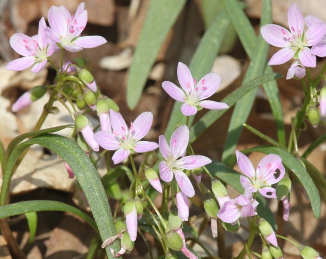
Spring Beauty are at their peak with hundreds of flowers visible from a single spot.


Perhaps the most colorful display is presented by the Marsh Marigolds.


Trout Lily, False Rue Anenome, and Blue-eyed Mary were also in flower. A few early trillium, phlox and a Jack-in-the-Pulpit hinted at more to come.

Sunday, April 11, 2010

Spring 2010 events


As Spring arrives in Southwest Michigan, there are lots of events planned near Kalamazoo:


April 17 Free admission to the Kalamazoo Nature Center

April 17 Annual Midwest Crane Count

April 18-24 Free admission to all National Parks during National Park Week. Indiana Dunes National Lakeshore; Sleeping Bear Dunes National Lakeshore

April 24 Earth Day Celebration. Saugatuck

April 23-25 Maple Syrup Festival in Vermontville

April 24 & 25, May 2, May 15 Kalamazoo River Valley Trail Spring Wildflower Walks

open through April 30 Meijer Garden butterfly display. Grand Rapids


May 1-8 Tulip festival. Holland

May 1 Spring blooms in the Dunes Hoffmaster State Park

May 1 Blossomtime Grand Floral Parade Benton Harbor/St Joseph

May 14 - 16 West Michigan Birding Festival. Luddington

May 15, 22 Kayak Demo Days at Ramona Park

May 22-23 Great Lakes Kite Festival Grand Haven

open now through May 31 Big, Big Bugs exhibit at Grand Rapids Museum


It's also a great time to visit local wildflower sites


Other Spring possibilities:
10 Reasons to Love Spring Camping in Michigan

Thursday, April 8, 2010

US 131: The Michigan Roadside Naturalist

The Michigan Roadside Naturalist
by J. Alan Holman and Margaret B. Holman
2003
University of Michigan Press

While this guidebook, discussed earlier, covers the entire state of Michigan, one route goes directly through Kalamazoo. Their "West-Central Route" stretches from the state border to Petoskey. For this post, I've highlighted the southern section, close to Kalamazoo.

The West-Central Route [southern section]
Indiana border to Grand Rapids (US 131)

Features of this area: Rolling country, lakes and ponds, marshy lowlands, and wooded uplands on Wisconsinan end moraines. Reptiles uncommon in other parts of Michigan: eastern box turtle, black rat snake, massasauga rattlesnake. Ice Age fossils. Old Indian trails.

1. The Lakes
"US 131 passes mainly through a rather lakeless low ancient lake plain topography from the Indiana border until it reaches the higher Kalamazoo moraine upland area near the city. But one can find the lake country within a few miles of the highway." Reach the lakes by going west on US 12 to M-40 then north on county roads.

2. The Prairies
"The question of how prehistoric peoples used the small prairies crossed by U.S. 131 in St. Joseph and Kalamazoo Counties is intriguing. these prairies are small remnants of an extension of the 'prairie peninsula' that was an expansion of the vast prairies of Illinois across northwest Indiana and into southwest Michigan during the warm period known as the hypsithermal (around fifty-six hundred years ago)... The Potawatomi who lived in the area when the settlers arrived had villages and garden oriented toward the prairies."

Evidence of Hopewell Indians has been found near the highway.
Kalamazoo County had many prehistoric features known as garden beds. "These features consisted of earthen ridges about one and a half feet high and were reported to have been laid out in various formal shapes such as wheels and triangles, with spokes and patterned squares withe ridges facing first one way and then the other." There is no trace of these now.


3. Schoolcraft Area Mastodont
"A mastodont find occurred in 1995. The bones were found when a local family was digging a canal." (More commonly known as a mastodon)

4. Plainwell Area Mastodont
In 1945 a relatively complete mastodon was found on the Keith farm. "One of the unsolved mysteries about the occurrence of these giant, elephant-like creatures is the fact that most of them are discovered only as individual bones or parts of bones or teeth. One of the suggestions as to the reason for this is that Ice Age hunters killed animals that were mired in quaking bogs, butchered them at the site, and then carried most of the parts away, leaving the unused parts such as the skull and teeth in or near the kill site."

5. Prehistoric Grand Rapids
The Hopewell people built burial mounds (known as the Converse mounds) in what is now downtown Grand Rapids. These no longer exist. The nearby Norton mounds, 17 mounds near US 131, are now protected


You may find this book from Amazon, Barnes & Noble, or at your local library.

Sunday, April 4, 2010

Early blooms


Kalamazoo's wildflower season continues to develop with new species in bloom. Dutchman's Breeches (Dicentra cucullaria) will come to its peak over the next couple of weeks but a few early plants were already in flower.

Spring Beauty (Claytonia virginica) is flowering now and many more will open over the next weeks.


Hepatica, which was just opening a week ago, is near its peak now. New leaves, which appear after the flowers, were just starting to emerge.

We also saw a few really early blooms from Marsh Marigolds and Trout Lilies at the Kalamazoo Nature Center this week.

Thursday, April 1, 2010

Michigan Roadside Naturalist


The Michigan Roadside Naturalist
by J. Alan Holman and Margaret B. Holman
2003
University of Michigan Press

This guide to Michigan is rooted in science. Both authors were associated with MSU's musuem; he was a herpetologist and she an archeologist. The first half of their book presents an overview of Michigan's geology, wildlife, and archeology. The second half identifies natural, archeological, and geological sites along seven routes that cross the state.

I learned a lot from this book. For example, Kalamazoo is south of the Mason-Quimby line, which means mammoth and mastodont (or mastodon) fossils are found in this region, as are fluted spear points of Paleoindians. Humans arrived in the area about 12,000 years ago, after the glaciers of the Ice Age had receded. Later area residents (about 2000 years ago) were part of the Hopewell culture of mound builders.

Kalamazoo is also in the Carolinian Biotic Province, while northern Michigan is in the Canadian Biotic Province, with a transition zone starting just north of Grand Rapids. (From the highway, the number of white birches signals this transition.)

"In geological terms, Michigan is a mass of unconsolidated Ice Age sediment, averaging about 25 to one hundred feet thick and several thousand years old, lying on consolidated layers of ancient bedrock thousands of feet thick and many millions to more than a billion years old." Geological uplift and subsequent erosion, erased about 290 million years of Michigan's fossil record, which means while ancient corals like the Petosky Stone and comparatively recent Ice age fossils are found in Michigan, the dinosaur fossils are missing.


Michigan Highway Trips
1. The Lake Michigan Route
Indiana Border to Mackinaw City (I-94 to US 31)

2. The West-Central Route
Indiana border to Petoskey (US 131)

3. The Central Route
Indiana Border to Mackinaw City (I-69 to US 27 to I-75)

4. The East-Central and Northern Lake Huron Route
Ohio Border to Mackinaw City (US 23)

5. Southeastern Michigan and the Thumb
Ohio Border to Bay City (I-75 to I-94 to M-25)

6. Upper Peninsula, Lower Route
Mackinaw City to Ironwood (US 2)

7. Upper Peninsula, Upper Route
St Ignace to Wakefield (I-75 to M-28)


Available from Amazon, Barnes & Noble, and many libraries.